home - where
- snorkel/dive - hire
prices - safety suits - sea
conditions - Goat Island - café
- aquariums - schools
| Swimming at Goat Island has become hugely popular, drawing many hundreds of thousands of visitors each year. But the visit can become disappointing in the wrong sea conditions. By means of this page we hope to give uptodate information about the weather and sea at Goat Island and around Leigh. Please make sure to verify that the information is current, by checking the date of last update. Bookmark this page and tell others about it. Please note that you may need to reload the page in order to obtain the latest update. |
home - where
- snorkel/dive - hire
prices - safety suits - sea
conditions - Goat Island - café
- aquariums - schools
| Date Tuesday 16 December, 2014. 09:00 NZ daylight saving time
Time. Low tide at 08:00,20:30(1.0-2.8m).
Condition: UNSAFE,BAD,POOR,FAIR,GOOD,VERY GOOD, EXCELLENT, This is what the sea
looked like this morning:
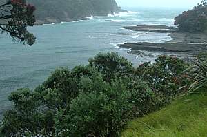 Goat
Island Overcast with strong SE wind & waves.Visibility poor
(1-3m) . Temperature 18ºC. The water is warming again
but you still need a thick long wetsuit and hood for 2 hours of discovery
and fun. Tall waves E of the channel but calm in Alphabet Bay. Lots of
broken seaweed in the shallows. Swell developing. Goat
Island Overcast with strong SE wind & waves.Visibility poor
(1-3m) . Temperature 18ºC. The water is warming again
but you still need a thick long wetsuit and hood for 2 hours of discovery
and fun. Tall waves E of the channel but calm in Alphabet Bay. Lots of
broken seaweed in the shallows. Swell developing.
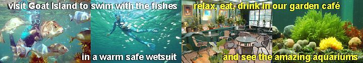
The Seafriends centre is open for the new season. We've been renting the best safest gear for over 20 years! Café open 9-4PM every day. Bookings welcome. Great coffees; tasty meals. Watch our movie/slideshow on YouTube: The Fishes of Goat Island, part1, part2. 27 minutes. Shows the common fishes of Goat Island, with narrative and subtitles that translate into many of the world's languages. A snorkeldiver lasts for 25 minutes without, but for 2-3 hours in our
5mm unisuits with hood. $30 all gear all day 9AM-7PM! Discounts for groups
or families Discover Goat Island.
Matheson Bay: calm but murky. Whangateau estuary: Clearest around high tide. Snorkel in the Whangateau estuary around high tide, sheltered from westerlies and northerlies. Visibility at high tide not monitored, but less than Goat Island. Outlook:
Snorkel hire: cheapest, cleanest, huge choice, many sizes and optical masks for short- and long-sightedness. Visit Seafriends at the top of the Goat Island Rd for the best deals, most choice and cleanest gear. When the sea is still cold, most snorkel pleasure can be attained by wearing our fully covering double thickness 5mm wetsuits. A complete set is only $30 for the day, including a hood! Stay warm, stay safe, stay out of the sun, stay comfortable in a single long safety wetsuit (unisuit). Family and group discounts offered. Additional hoods are free. Optically corrected masks -8 to +4 diopters. Bright night-dive torches for night snorkelling. Take a warm shower after the dive, at Seafriends. No need to starve or go thirsty because the Seafriends Café is open 9-4 with great coffees and fresh food. Lots of information and marine aquariums to explore. Bring family and friends to camp nearby. Help our education centre and help our local community! Remember, we
are the people fighting to save our seas - YOUR sea, your children's sea.
Find out why, on our web site. Support Seafriends!
|
How do I know at what date and time the photo
was taken?
Right-click on the photo and select view image.
Then right-click again and view properties.
This should show the JPEG/EXIF data, including
date-time taken and modified for Internet.
The daily photo is taken with a vertical polarising
filter for optimum penetration into the water.
Interesting links on this web site
Interesting external links
-- Seafriends home page --